With just a few days left in the school
year, it was time for the annual Stillaguamish Valley School year end
trip. The school has been doing the trips for 15 years but it's only
our 2nd time participating. Originally, I thought
everyone but Jacob would be going because it looked like it was a
Friday-Sunday trip which meant Dode could take his birthday leave and
Anastaya would miss one day of school. When we found out the trip
was Friday-Monday, Dode and Anastaya had to miss it as well. We did
bring an extra, one of Isaac's friends from school. The trip took
place at Camp Wooten Environmental Learning Center near Pomeroy, WA.
The Friday of the trip was the last day
of seminary (early morning religious instruction for the high
schoolers). I've been picking up a van full of teenagers and
delivering them to the high school for most of the school year. I
dropped the kids off with a warm goodbye at 7:15 am and went home to
pick up everyone and head off, leaving town at 8:00 am.
We stopped in Tonasket for lunch and a covered wagon tour of the murals. Dode and I had planned to see those murals a few years ago when he had a work trip to the Tri-Cities. We never made it because our car broke down on the road to Tonasket. This time, there was no car trouble. We arrived in town a little early and since I love to try new places to eat when we travel, I'd found an ice cream/popcycle shop online with good reviews. I could not find it based on the address I found online and gave up. I'd also found recommendations to stop at the Blue Sky Market for fresh tortillas. We'd been driving for a long time so I kicked the kids out of the car at a shady park to let them stretch their legs and I drove around until I found the small market. (It ended up being two blocks away from the park I left them at!) In the back of the market were two women running a tortilla machine. The packages I purchased were so fresh, they were still warm. They were thick and tasty. After picking up the kids, we parked for the covered wagon tour and discovered the popcycle shop right across the street. They had about 30 different kinds of popcycles. They really hit the spot on a hot day.


The girl on the end is Isaac's friend Christie who went with us.

On the covered wagon, ready for the tour.
The man running the tour was from Marysville so he greeted every family with, "What's your address?" Everyone would pause a moment and then start rattling off their house number and street. The tour guide was just trying to figure out if he was familiar with the area we were from, but just asking for addresses doesn't really help. I told him, we live between Hwy 9 and the Arlington Cemetery. He knew right where that was.

Miriam and William got to ride on the front seat for part of it.

Miriam getting to drive the horse team.
The man running the tour was pretty laid back. The kids would be steering the horses all over the place, into oncoming traffic and cars would have to move out of the way. When he stopped at one mural, the child holding the reins was pulling on them too hard we we started going backwards. The car behind us had to back up too or it would have been front ended! Isaac and I didn't feel very safe when we stopped for several minutes with the wagon straddling the train tracks. At the start of the tour we'd had to wait for a train going on those same track. We spent more time looking up and down the tracks than looking at the mural!

One of the murals. The building face is actually flat. Tonasket has a "mural in a day" every year where they bring in a bunch of artists who complete a mural in just one day. They've been doing it for years to boost tourism.

Isaac and Christie trying to occupy themselves in the car. When they weren't taking silly photos, they were sleeping.
So far so good, the trip was going great, we were making good time. I enjoyed the big vistas of rolling hills throughout Eastern Washington. I thought to myself, "I love road trips, why has it been so long since we've gone on one?" The trip started to go downhill when we left Dayton. The GPS led me about 10 miles out of town before directing me to turn up a dirt road. I knew we were heading to the largest environmental learning center in the state and figured it would not be up a dirt road. “Oh no you don't”, I thought. “I've read stories about people who get lost listening to their GPS”. So, I made a U turn and went back to the highway, forcing the GPS to recalculate my route. We backtracked to Dayton where I'd turned off the main highway and started over. I drove about 20 miles until we reached a road with a sign for Camp Wooten. I was happy I had not listened to the GPS. I turned down this road with a smug smile on my face.
We went about 15 miles further down that road when the GPS again directed us to turn down a dirt road. Since this was the 2nd time the GPS had directed me to a dirt road, I decided that it must be my only choice, and maybe the GPS was correct the first time. Big mistake! We spent 90 minutes on extremely rugged dirt roads, passing signs warning vehicles to not attempt pulling trailers on this road, gaining tons of elevation only to lose it as we twisted and turned through the hills between Dayton and Pomeroy. Portions of this road were more accustomed to seeing high clearance vehicles than seeing a 12 passenger van filled with a single mom and a bunch of kids. We never passed another car the entire time. There were "No Trespassing" signs lining the road on both sides. Isaac started getting worried that at some point we were going to break down and he was going to be forced to walk to find help. After a while, I knew there was no way a large camp was up this road but I didn't want to turn around, hoping the GPS would come through for us. After the roads became progressively more rough and narrow, we came to a T in the road and made it to more maintained gravel roads. Driving about a quarter mile down the road, the GPS said we had arrived close to 6 pm, nearly 10 hours after leaving Arlington.
We went about 15 miles further down that road when the GPS again directed us to turn down a dirt road. Since this was the 2nd time the GPS had directed me to a dirt road, I decided that it must be my only choice, and maybe the GPS was correct the first time. Big mistake! We spent 90 minutes on extremely rugged dirt roads, passing signs warning vehicles to not attempt pulling trailers on this road, gaining tons of elevation only to lose it as we twisted and turned through the hills between Dayton and Pomeroy. Portions of this road were more accustomed to seeing high clearance vehicles than seeing a 12 passenger van filled with a single mom and a bunch of kids. We never passed another car the entire time. There were "No Trespassing" signs lining the road on both sides. Isaac started getting worried that at some point we were going to break down and he was going to be forced to walk to find help. After a while, I knew there was no way a large camp was up this road but I didn't want to turn around, hoping the GPS would come through for us. After the roads became progressively more rough and narrow, we came to a T in the road and made it to more maintained gravel roads. Driving about a quarter mile down the road, the GPS said we had arrived close to 6 pm, nearly 10 hours after leaving Arlington.
Did we rejoice? Nope! The finish line was just a spot on a gravel road with no campground in site. We backtracked two miles to the T in the road that listed two campgrounds each two miles away, but not Camp Wooten. Everyone had to go to the bathroom due to our lengthy drive so I made a 50/50 choice and headed to the left. We arrived at Tamarack campground and started driving around looking for a bathroom. We found lots of RVs but no bathroom. I started driving down a narrow paved road, leaving the campsites behind. I figured I was on some kind of maintenance road and was sure that at some point I would have to turn around. We got to the first wide spot in the road where I could turn around and a sign appeared before us, “Camp Wooten Environmental Learning Center”. The car broke out into applause and cheers. Somehow, we had managed to navigate our way to the campground through pure luck!
As the evening progressed, we saw that every family that used a GPS or Cell Phone got misdirected either onto the the first dirt road the GPS had told us to turn on or the road we chose. The only people who didn't get lost were the two teachers who traveled together with a paper map.
As the evening progressed, we saw that every family that used a GPS or Cell Phone got misdirected either onto the the first dirt road the GPS had told us to turn on or the road we chose. The only people who didn't get lost were the two teachers who traveled together with a paper map.
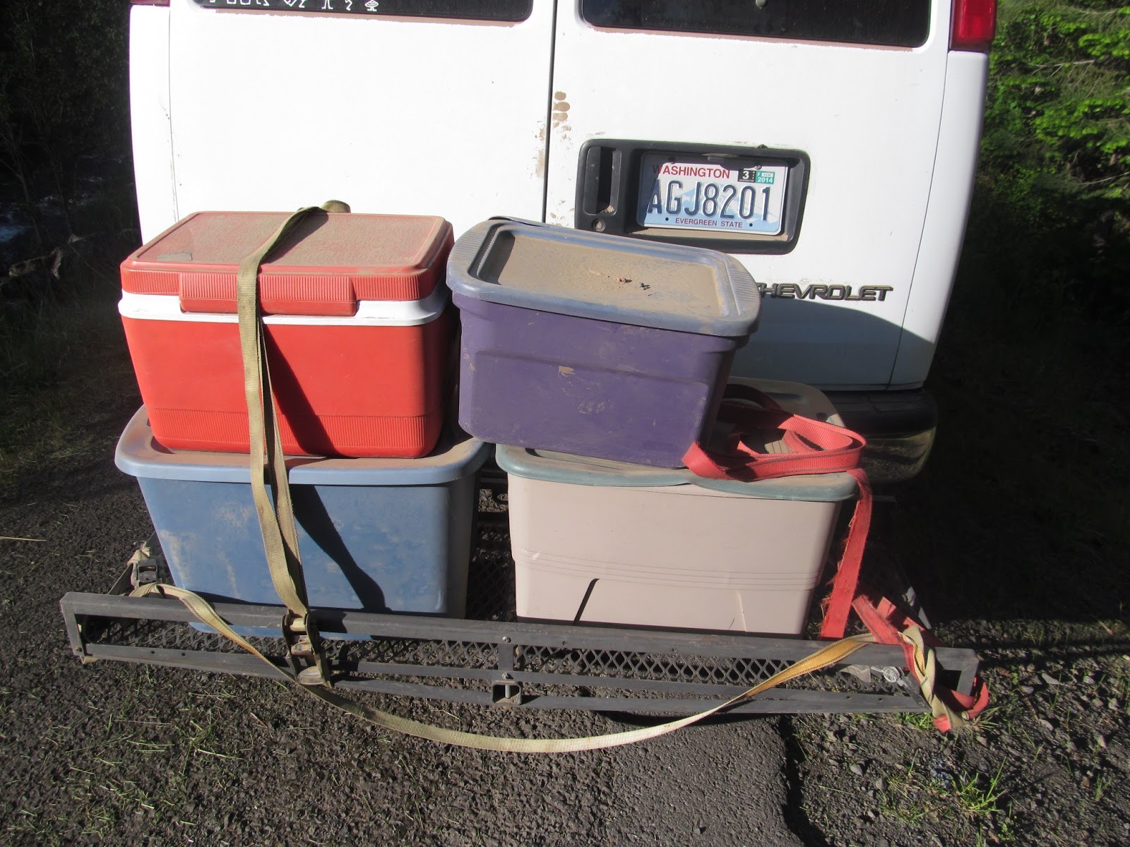
As I was driving the dirt roads, I wondered how the bins were doing. I decided that if I'd lost one somewhere, I was not going back. When I checked the back of the van at the campground, this is what I saw. Two of the three straps had come loose! I don't know HOW I avoided loosing anything.


Our Cabin.
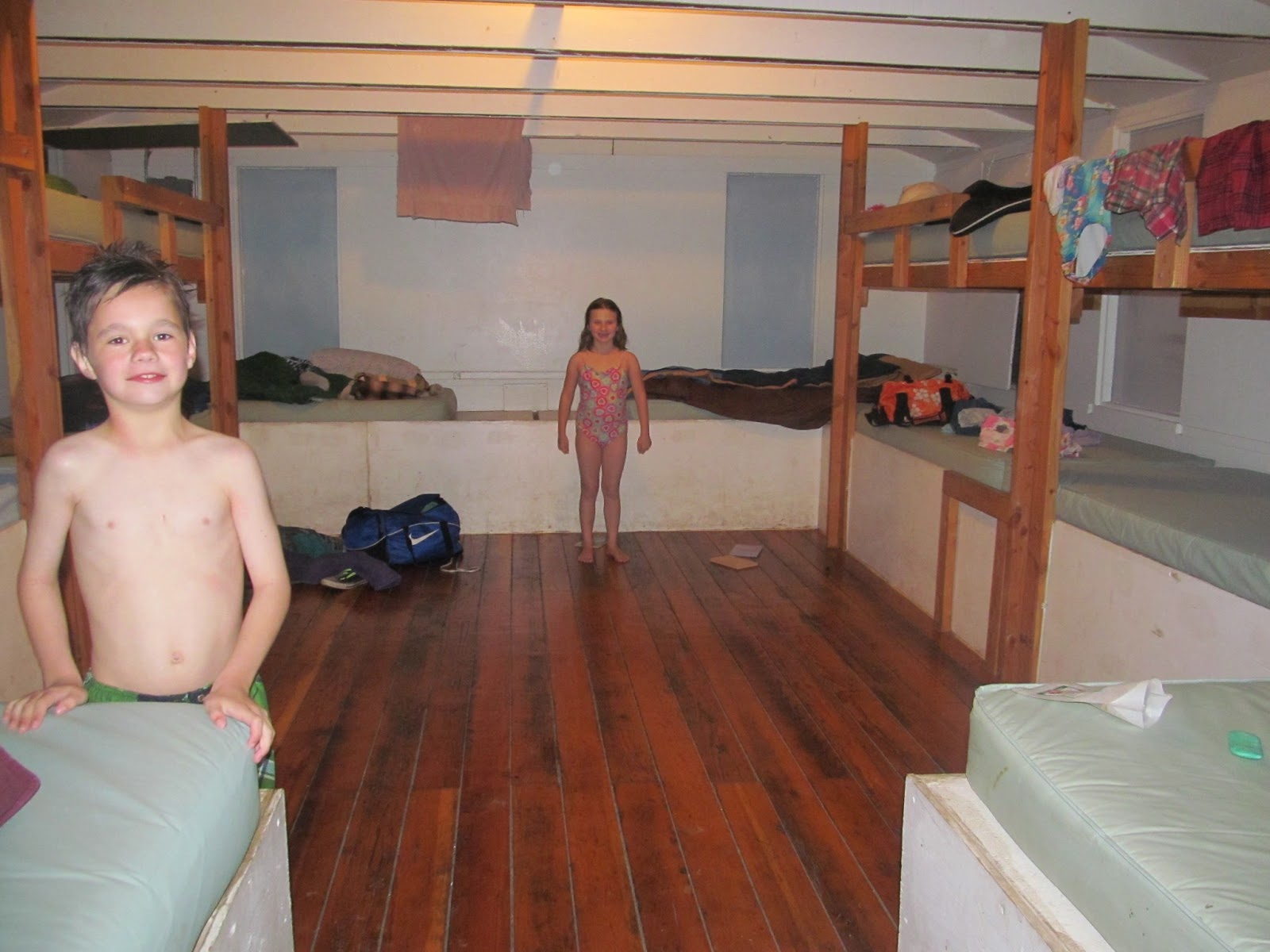
Inside the cabin. It sleeps 12, there were only 6 of us.
We were soon settled into our cabin that would be our home for the next three nights. The cabin could sleep 12 so being there with just 6 of us, it felt pretty empty. As we were laying in bed that night, I teased Miriam that I wished our family was big enough to fill all the beds. She thought it sounded like a good idea since that would mean she wouldn't be the littlest anymore.

View across the grounds from our cabin. The pool is on the right, the mess hall is on the left.

The covered pool. We spent hours here.


I think I bought these goggles as much for me as for her. They make me smile every time I look at her. She can't see through them very well so she takes them off to see where she wants to walk to and then puts them back on once she's there.

The Dicksons jump in together.
Saturday morning we ate breakfast and set off to Pomeroy where they were celebrating Pioneer Days with a parade. I'd been told there was a paved road out to the main highway and was determined not to let the GPS get me off course again. About 10 miles down the paved road, a sign pointing to Pomeroy told me to turn left, onto yet another dirt road. I white knuckled the decision and pulled off the road, unsure what to do. Another family from the school pulled up. They had a brochure from the camp which explained that the shortest route to Pomeroy went over a road which was 2 miles of dirt, the rest paved. Trusting in the brochure, we set off on the dirt road. I sure breathed a sigh of relief when we made it back to asphalt after those two miles of dirt road. The children were pretty excited too!
We made it to Pomeroy with plenty of time to spare before the parade began.

10 minutes before their pioneer days parade began. Not a lot of competition for seating!

Miriam started crying because she wasn't fast enough to grab the candy. One of the floats went by and as they paused in front of us, a man noticed her tears. He started inundating her with candy.
After the parade, we visited the Grant County Historical Museum. It was a mostly organized assortment of things that had been saved in attics and back rooms for the last hundred years. After viewing the artifacts, we saw a sign for a used book store. The book store owners were so nice. They had a restored telephone booth that they let the children use. It was hooked up to telephone service so one child could call it with the store phone and talk with the child in the booth. They had a 50 cents toy bin that I let William, Miriam and Elizabeth get something out of. We spent 30 minutes in their store and spent less than $5. I don't think they could stay in business long with customers like us!


Yes, I know I'm cheap. I bought two scones (50 cents each) and we shared them four ways.

Usually the children are in front of the place of interest. This time, it was our trusty van.
We received a guided tour of this late 1800's flour mill.

After the mill, we headed to the Pomeroy fairgrounds to the agricultural museum. We got to pretend we were horses and turn the crank round. One revolution was enough in the heat!

4 Dicksons on a tractor.

Climbing on tractors makes for dirty fingers!
For as cheap a family as we are, I can't believe how much money we've spent over the years buying fishing poles on camping trips. This trip was no exception. The campground we stayed at had a stocked pond but you had to bring your own pole. We had to make a quick stop at the hardware/housewares/ ice cream shop store in Pomeroy to buy their cheapest poles.

View from the section of dirt road between Pomeroy and our camp.

I had to get a photo of this genius idea! If you've never tented it, it probably doesn't mean much to you. I've spent more time than I'd like crouching on less than clean bathroom floors trying to dry my hair in the hand dryer. Mounting one high on the wall is such a mercy!

The children enjoyed cooling off in the sprinklers that irrigated the grass each night.
Rainbow Lake, a few miles down from the camp, had a kid's fishing derby. Everyone from camp went down to try their luck.

Mr. Jones (a teacher from the school) helps Miriam get her fishing pole ready.
Within a few minutes, William had managed to tangle his line with Miriam and another child's. We spent three hours at the lake in the hot sun. Fishing was constant work with re-baiting hooks and untangling lines. In that time, Miriam and William never got a bite. Elizabeth caught two fish.

Helping with the fishing poles. Isaac said that going fishing reminded him of how much he hates it!
They had a raffle at the end of the fishing derby and had so many prizes, each child got one. Both Miriam and William got a hat. Elizabeth got a fishing pole.

Touring the Toucanan hatchery. They stocked the lake we fished at.

We spotted this big horn sheep on the hill behind the hatchery. I also saw two moose in the field next to the hatchery. I found the mammals more interesting that the fish.

A ranger led mammal program back at camp.

We hiked the nature trail at the camp. It was a steep trail with loose rocks and many switchbacks. Miriam did it in high heels and a skirt.

Isaac looking majestic on the switchback above us. He wore the purple cape the entire weekend.

You can barely see the camp in the clearing just above the middle of the photo. The pond in the front is the pond the kids could fish at or canoe on.

Taking a break near the top. She isn't listening to music, she's listening to her favorite audio books, The Penderwicks. I think she's listening to each of the three books 100 times.

At the bottom of the trail, we've made it!

Miriam gathered a bouquet of flowers and leaves along the trail.

There were hundreds of butterflies at the camp, six different species.

I think the Palouse area of Washington is beautiful.
Monday morning we cleaned up our cabin and set off for home after breakfast.

Driving home, looking so enthused.

Chocolate the Bear on the ride home with some swag we picked up.

A vacation isn't a true vacation without ice cream! We stopped for ice cream at Country Mercantile near Pasco. Elizabeth chose caramel brownie explosion.

Miriam chose gummies. She was excited they came with a bonus hair bow!

We saw a lot of this on the way home.
We made the time go by quicker by listening to Madeline L'Engle read A Wrinkle in Time. The drive home was much better than the drive there since we didn't take a "scenic" detour. The teacher who planned the activity thought the camp was wonderful is an planning on making it an annual event. We had a good time too and I'm willing to go back, now that I know the correct way!